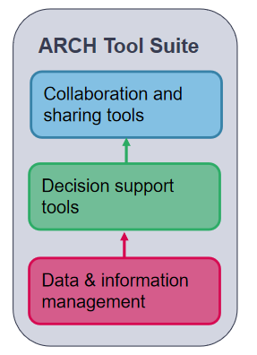
ARCH Solutions
ARCH is developing tools and methodologies to improve the resilience of historic areas to climate change-related and other hazards. These tools and methodologies are developed together with the pilot cities of Bratislava, Camerino, Hamburg and València, in a co-creative approach, which involves local policy makers, practitioners and community members.
This page provides an overview of the forthcoming ARCH solutions. For more details about them, please read deliverable 7.4 ‘End-user requirements to ARCH tools and methodologies’.
Disaster Risk Management framework and resilience assessment dashboard
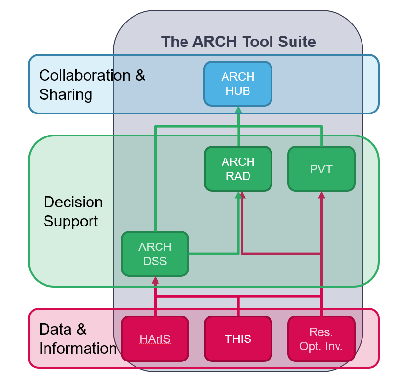
The main output of the ARCH project is a coherent, overarching and unified ARCH Disaster Risk Management Framework for historic areas that takes climate change adaptation, heritage management, and social justice into account. The ARCH Resilience Assessment Dashboard RAD is a web-based tool to assess how well the DRM framework is implemented.
The ARCH RAD enables end-users to perform thorough or quick resilience self-assessments for historic areas.
The framework and RAD will complement and build on the Ten Essentials for Making Cities Resilient, the Sendai action plan and the RAMSES Transition Handbook. Based on the Disaster Resilience Scorecard for Cities, they will be tailored for historic areas and will take into account chronic stresses from climate change, as well as acute shocks from natural hazards.
Data capturing and information management
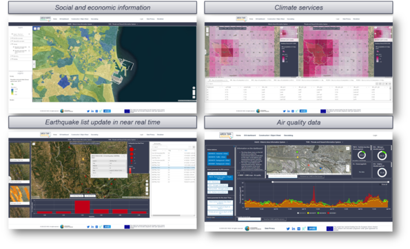
The models and data needed to make informed decisions to reduce risks from climate change and other hazards are not always available, or are not available in a form that is useable to decision-makers. Data will be collected from surveys and monitoring systems through satellite, aerial and ground sensors. As well as data about the condition of the historic areas and objects, information on hazards will also be included, such as rainfall, water level, probability of earthquake occurrence, air temperature and atmospheric gases.

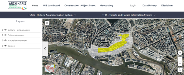
The captured data will be fed into information management systems. The Historic Area Information System HArIS is a database of geo-referenced information of historic areas. HArIS enables end-users to access geo-referenced information about historic and current conditions of historic areas. It links both 3D geometry and material information, where possible, enabling structural resistance and simulated ageing analysis when combined with short and long term evolutions of air quality and climate data.
The Threats and Hazard Information System THIS is a database of geo-referenced environmental threat indicators. THIS enables end-users to access geo-referenced information about historic and real-time environmental threat indicators for historic areas.
Risk-oriented vulnerability assessment
Building on risk-oriented vulnerability assessments developed as part of the RESIN and CIPRNet projects, ARCH will develop a Decision Support System (DSS) tailored for historic areas.
The IVAVIA method, developed as part of the RESIN project, will be adapted to take into account the specific regulatory and societal conditions of historic areas, and the CIPCast DSS from the CIPRNet project will be embedded within the IVAVIA process.
The ARCH Decision Support System is a web-based, geographical information system (GIS) platform. It enables end-users to conduct scenario and risk analyses for historic areas with regard to natural hazards. The ARCH DSS will combine data gathered from different sources to allow constant monitoring of historic areas as well as to predict risks and damages. This will give users a fully tool-supported process to conduct risk analysis for historic areas.

Resilience measures inventory
Measures to build resilience will be needed to respond to the results of the impact and risk assessment. For this, a collection of measures and pathways to implement these measures will be provided along with methods of assessing their usefulness and options for how to finance them. This will provide guidance in prioritising options and designing resilience pathways.
The ARCH Resilience Measures Inventory provides end-users with access to harmonised information about resilience-building options. It will enable end-users to identify suitable opportunities to increase resilience for heritage areas.
The Resilience Pathway Visualisation Tool is a graphical tool to design resilience implementation plans. It will enable end-users to visualise resilience pathways in order to build on resilience by identifying, prioritising and sequencing resilience measures for implementation.
Finally, the Inventory of Funding Opportunities identifies public and private funding options, favouring sustainable and ethical financial solutions, in order to define and implement best practices for financing the implementation of resilience plans. New financing forms, like crowdfunding or climate bonds, have been evaluated for their suitability.


Collaborative, web-based disaster risk management platform
The collaborative platform, ARCH HUB, bundles all the ARCH tools. It helps urban practitioners and local authorities create and implement sustainable protection and reconstruction strategies. The platform enables collaborative management of the resilience building process and allows the sharing of best practices by providing access to specific user groups.